notes.husk.org/likes
images.
tagged aerial view.
page 10 of 13 with 305 images.
rocket
launchpad
space exploration
aerial view
nasa
aerospace
kennedy space center
black and white photography
space program
launch complex
Dan W, Software Developer
aerial view
oil refinery
storage tanks
industrial architecture
pipelines
petrochemical plant
top-down perspective
geometric pattern
industrial infrastructure
fuel storage
rachelbinx
satellite imagery
aerial view
desert landscape
geology
topography
arid terrain
erosion patterns
earth tones
aerial photography
terrain texture
TO INFINITY & BEYOND
detroit
aerial view
urban planning
data visualization
city map
downtown detroit
parking map
urban infrastructure
satellite imagery
city layout
Notational
satellite
netherlands
stars
aerial view
latitude longitude
fav
manmade
Satellite Delight
manhattan
new york city
nyc
data visualization
architectural visualization
skyline
aerial view
urban planning
3d modeling
cityscape
jomc.links
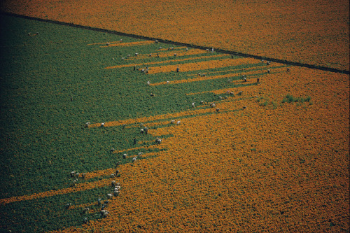
aerial view
agriculture
pattern
landscape
sunflower field
contrast
crops
texture
geometric
nature
Tecznts
airport
architectural rendering
aviation
aircraft
runway
terminal
urban planning
black and white
geometric
aerial view
Fuck Yeah Brutalism
satellite imagery
aerial view
coastline
delta
river mouth
estuary
ocean
geography
landscape
nature
Landsat
satellite imagery
aerial view
coastline
ocean
bay
estuary
geography
nature
inlets
topography
Landsat
satellite imagery
aerial view
coastline
ocean
shoreline
nature
landscape
geography
topography
sea
Landsat
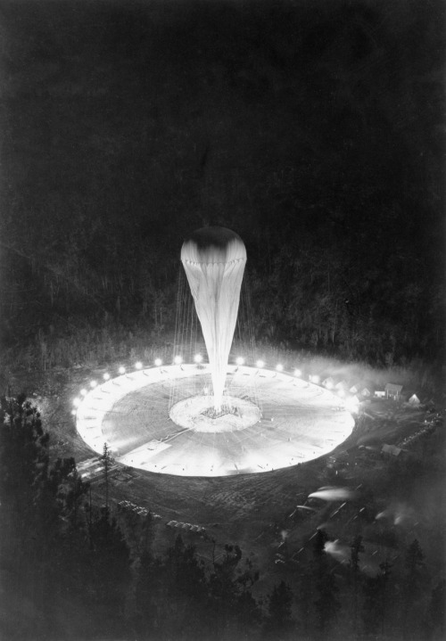
black and white
night photography
aerial view
balloon
illuminated
spotlights
forest
launch site
high contrast
science experiment
Tecznts
satellite imagery
islands
cloud cover
ocean
aerial view
earth observation
meteorology
sea
nature
geography
Tupperwolf
night vision
drone footage
soccer field
aerial view
thermal imaging
uav
surveillance
infrared
sports field
night photography
One Visible Future
mountain
foggy
forest
radome
landscape
mist
satellite dish
cliff
aerial view
nature
Tecznts
aerial view
satellite imagery
3d mapping
bay
coastline
geography
maritime
landscape
waterway
infrastructure
The New Aesthetic
greenhouse
hoop house
high tunnel
agriculture
farming
polytunnel
crop cultivation
farmland
aerial view
plastic tunnels
Dan W, Software Developer
architectural visualization
aerial view
parametric design
urban design
concept architecture
landscape design
3d rendering
futuristic architecture
site plan
modern architecture
Department of Design
aerial view
landscape
404 error
surreal
conceptual art
drone photography
muted tones
minimalist
desolate
scenic landscape
cityscape
urban landscape
quote
bruce sterling
aerial view
urbanization
typography
density
metropolis
sociology
BruceS
cockpit view
head-up display
fighter jet
aviation
flight instruments
military aviation
aircraft
aerial view
flight simulator
cockpit instrumentation
Fresser.
satellite imagery
aerial view
compass rose
airplane silhouette
geometric pattern
desert landscape
ground art
mysterious
top down view
earth view
Tecznts
london
aerial view
big ben
houses of parliament
river thames
black and white
cityscape
westminster
architecture
bird's eye view
One Visible Future
fog
mist
coniferous forest
sunbeams
god rays
aerial view
sunrise
golden hour
atmospheric
landscape
Dan W, Software Developer